Estimating the Wealth of Households
Project description
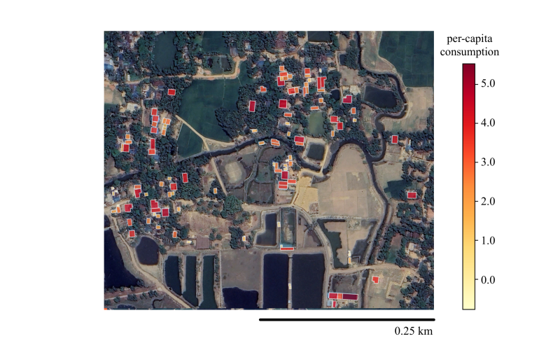
A wide range of government policies and humanitarian interventions are designed for and targeted to specific households: within a village, some households will be eligible for benefits while others will not. However, accurate, up-to-date, and standardized estimates of household level well-being are exceedingly rare in most low- and middle-income countries. While recent advances in geospatial analysis have shown that satellite imagery can be used to measure regional wealth, these estimation methods aggregate over entire villages, or grid cells of a few square kilometers – spatial scales at which significant heterogeneity in wealth and poverty may exist.
We leverage recent advances in machine learning, paired with ultra high-resolution satellite imagery and geolocated household survey data, to estimate the well-being of individual households, at the scale of entire countries. We find that these ultra-granular poverty estimates can meaningfully differentiate between poorer and wealthier households within a village. We also show that this new approach can improve the performance of programs that seek to target benefits to the poorest households in a society, relative to approaches that only leverage regional-level wealth estimates. To enable and measure progress toward the first UN Sustainable Development Goal — ending poverty in all its forms everywhere — requires accurate and timely estimates of economic conditions. This work develops and tests a new approach to estimating the wealth and poverty of individual households, which leverages recent advances in machine learning and ultra high-resolution satellite imagery. This approach is vastly cheaper than current approaches that rely exclusively on household surveys, and much more granular than current state-of-the-art methods for estimating regional wealth from remote sensing data.
Related Publications
- Aiken, E, Rolf, E, and Blumenstock, JE (2023). Fairness and Representation in Satellite-Based Poverty Maps, International Joint Conference on Artificial Intelligence (IJCAI 2023) [pdf]
- Chi, G, Fang, S, and Blumenstock, JE (2022). Microestimates of Wealth and Poverty for all Low- and Middle-Income Countries, Proceedings of the National Academy of Sciences, 119(3), 1-11 [pdf]


